I got my first telescope in 2017, in time for the Great American Eclipse. I started paying attention to the concept of light pollution, including finding detailed maps of what places had high or low amounts of light pollution. After looking up nearby areas that were potentially good for stargazing, I got curious, and started just looking around at what all the light pollution was from. Of course, the vast majority of light pollution is from cities: street lights, industrial zones, parking lots. But sometimes, it’s from something else.
Maine
My first find was when looking over my home state of Maine. At first glance, everything looks normal. Bright spots for the two biggest cities, Portland and Bangor. Scattered lights over the whole coast. Pitch black over Baxter State Park.

But wait, what’s that other bright spot? It looks almost as bright as Portland. I’m not familiar with a city there.

Zooming in, we can see that it is… nothing. Just a bend in a river.

Switching to google maps satellite mode, we can see that there definitely isn’t a city there. But there is this large, flat building.
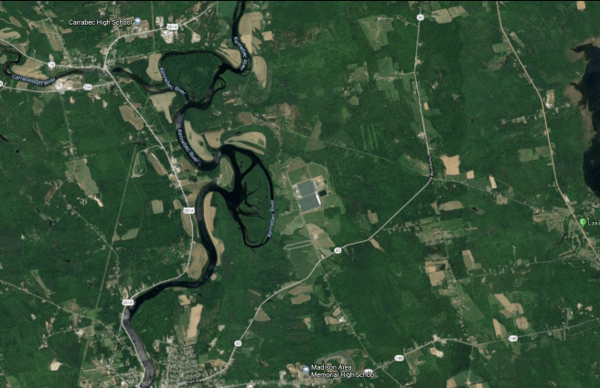


What kind of building produces a city’s worth of light pollution? At the time it wasn’t labeled on google maps, so I switched to street view and tried to find signs. I googled random guesses. Somehow, I found it. It’s a tomato farm called Backyard Farms. The tomatoes are in a massive green house. And while most of the time the tomatoes grow by sunlight, the winter hours in Maine are very short, and so this greenhouse augments its growing season with an enormous array of yellow lamps. And this makes it the single greatest source of light pollution in the entire state.
North Dakota
If you looked at this light pollution map of the United States, you might start to wonder after a minute; what is this sprawling metropolis in North Dakota?
Zooming in, we can see that its location is not the only odd feature. While the light pollution of most urban areas is relatively smooth and peaks in a small number of central places, this phenomenon seems to be quite blotchy.
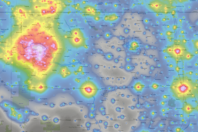
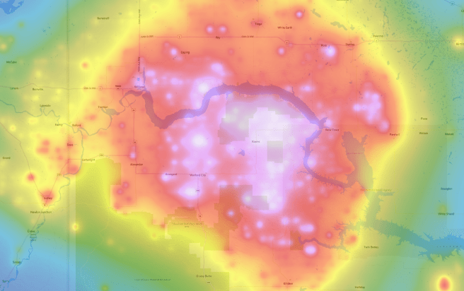
Again, switching to google maps, we see an intense lack of urbanization. Zooming in all the way reveals the truth.


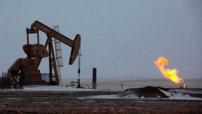
If you don’t recognize the shadow, this is an oil field. The light pollution comes from the associated gas flares. These flares are deliberate, continuously burning fires, and they convert methane, a potent greenhouse gas, into CO2, a much less potent greenhouse gas.
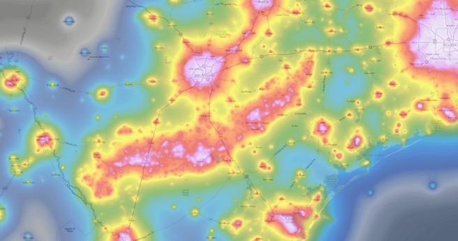
While the entire subject is rife with controversy, oil fields continue to shape our landscapes. Here’s a strange looking nebula in Texas.
And here is a constellation of offshore oil rigs in the Gulf of Mexico.

Hawaii
Lastly, I was wondering to myself what the light pollution around Mauna Kea looked like. Mauna Kea is a mountain in Hawaii that hosts a dozen of the world’s finest astronomical observatories. It has near-perfect viewing conditions, including being above most of the water vapor in the atmosphere. But it still shares an island with two hundred thousand people, who are producing a noticeable amount of light. So what does the map say?
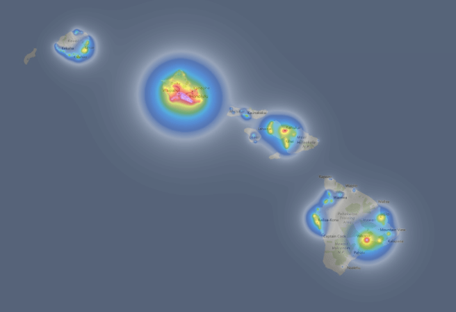
Panning over to Hawaii, we see that Honolulu is by far the biggest source of light pollution. Fortunately, it’s over 200km away from Mauna Kea, and doesn’t contribute to light pollution there. But the big island does seem to have its own major source. What could it be?

Zooming in, we see that it’s pretty point-like, symmetric and centralized. But there’s no city there.

Instead, there’s a volcano. Kīlauea, as an active volcano, regularly has literal glowing lava occupying the caldera. The amount of light changes with the level of eruption activity. Fortunately, at least according to the map, the light pollution doesn’t quite reach the summit of Mauna Kea.

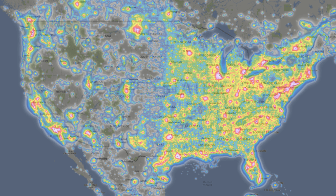
Like daytime satellite mapping, night time light pollution maps are an extremely useful tool. Their uses go beyond recreational exploring and picking a good place to use your telescope; they can be used by environmental scientists to track wildfires, by economists to estimate GDP of countries, or by intelligence agencies to detect undisclosed industrial facilities.
Can you find any mystery light sources on the map?

Arizona weird light pollution areas (using Google Maps ‘Plus Codes’): 85484WJ8+H3 a government “Boundary Camp” at the edge of Organ Pipe National Monument, H6V5+JF Shonto, Arizona the “Inscription House Health Clinic” on the Navajo Reservation (and what looks like some farms/ranches further north along AZ 16?), and what looks like a little homestead in the middle of nowhere, west of Leupp (via an actual link) https://goo.gl/maps/V8QnaBkovsxx4MQi9. Arizona is supposed to be dark-sky, but it has become harder and harder to find anyplace to see truly dark skies, even near Flagstaff. The old(ish) maps on the Light Pollution Map page show that we are dotted with little cities and ever-growing metropolises of light, and it’s sad that we can’t control it.
LikeLike
Check out North Korea vs South Korea by night 🙂
LikeLike
The chain of lights across the middle of this map of Quebec is a very large Hydroelectric Dam project, called the James Bay Project.
https://www.lightpollutionmap.info/#zoom=7&lat=7218859&lon=-8291733&layers=B0FFFFFTFFFFFFFF
LikeLike